Mobility limitations shouldn’t stand in the way of experiencing the beauty of Central Oregon. From river canyons to dramatic volcanic vistas and cascading waterfalls, the region offers outdoor opportunities designed with accessibility in mind. Below, we’ve rounded up a selection of accessible trails, many of which are written about in greater detail by Oregon Adaptive Sports.
Important Note: While these trails feature accessible infrastructure, individual abilities and outdoor conditions vary greatly. This is not a comprehensive list of all accessible spaces in the region, and trail conditions can change due to weather, erosion, or maintenance. We highly recommend checking current trail conditions and consulting with local resources like Oregon Adaptive Sports to ensure a safe, comfortable, and enjoyable adventure.
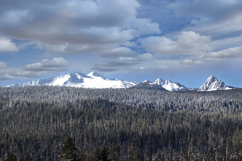
- Whychus Creek Scenic Overlook – Located just outside the town of Sisters, the one-mile Whychus Creek Scenic Overlook trail offers expansive, panoramic views of the Whychus Creek Wild and Scenic River area. On a clear day, the snow-capped peaks of the iconic Three Sisters dominate the skyline.
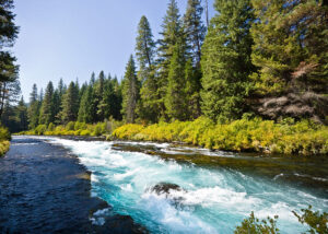
- Head of the Metolius Observation Site – Situated near Black Butte Ranch, the Head of the Metolius Observation Site features great scenery and informative interpretative signs along a short, 1/8-mile paved trail that is easy to navigate. It leads you right to the mesmerizing point where the river gushes straight out of the hillside.
- Dee Wright Observatory and Lava River Recreation Trail – Perched off the McKenzie Highway amidst a vast, historic lava flow, the Dee Wright Observatory and Lava River Recreation Trail provide stunning 360-degree views of the Cascade Range.
- Accessibility Note: Visitors using mobility devices may need assistance here, as there are a couple of shorter, steeper climbs to reach the viewing areas.
- Sahalie Falls – A bit farther out but entirely worth the trip, Sahalie Falls offers a paved trail ensuring visitors of all abilities can witness the sheer power of nature. Here, the McKenzie River plunges nearly 100 feet over a dramatic basalt cliff into a mist-filled basin.
- Salt Creek Falls – Located in Lane County, this is another must-see accessible waterfall. As Oregon’s second-highest single-drop waterfall, Salt Creek Falls offers a roaring, spectacular view from an easily accessible lookout platform.
- Ray Atkeson Trail at Sparks Lake – Heading past Mt. Bachelor, you’ll find this beautiful destination. The Ray Atkeson Trail features a paved, 1/3-mile section that leads hikers out to a magnificent mountain lookout facing South Sister and Broken Top.
- Walton Lake Trail – For a tranquil forest getaway, the partially accessible Walton Lake Trail in the Ochocos makes a complete loop around the water. The path takes you right through old-growth ponderosa pines and lush, green meadows.
- Rimrock Springs Wildlife Management Area – Located in the Crooked River National Grassland, the Rimrock Springs Wildlife Management Area features a unique wetland oasis. It can be accessed via a level, 0.5-mile paved trail that leads out to an uncovered observation deck.
- Crooked River Wetlands Complex -Close by the grassland, the Crooked River Wetlands Complex boasts 5.4 miles of walking, running, and hiking trails. Out of those, 3.25 miles are fully paved and open for use year-round.
- Dry Canyon Trail – The Dry Canyon Trail meanders right through the heart of Redmond. Along the path, you’ll find easy access to a variety of community parks developed for team sports, pets, disc golf, live music, and nature viewing.
- Smith Rock State Park – Even Oregon’s premier rock climbing destination has accessible paths. Smith Rock State Park’s Rim Rock Trails and North Point Loop are relatively flat, unpaved trails that still deliver those iconic, spectacular views of the sheer cliffs and the river below.
- Riley Ranch Nature Reserve – Situated on the northwestern edge of Bend, the Riley Ranch Nature Reserve is a historic ranch featuring open meadows, juniper and pine forests, unique lava flows, and a rocky canyon.
- Accessibility Note: It features 1.57 miles of smooth, soft-surface trail above the canyon floor, but note that the lower 1.25-mile Canyon Loop becomes quite rugged.
- Sunriver Bike Path – Woven throughout the community of Sunriver, the Sunriver Bike Path is an extensive, paved network of multi-use pathways perfect for smooth, level exploration.
- Bend Parks and Recreation Accessible Trails – Right in town, Bend Parks and Rec maintains a variety of excellent paved and ADA-accessible options:
- Tumalo Creek Trail at Shevlin Park: A scenic forested path following the creek.
- The South Larkspur Trail: Runs smoothly from Larkspur Park all the way to Neff Road.
- Pine Nursery Park: Features a nearly 2-mile paved loop popular with locals.
- Alpenglow Park: Offers 2.2 miles of dedicated, ADA-accessible paved paths.